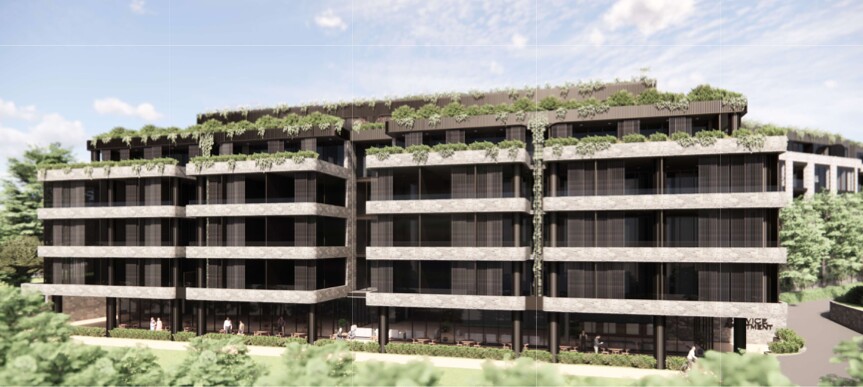
 Image of development from the EIS
142–150 Narrow Neck Road, Katoomba
The site of the proposed development is upslope from a series of swamps. These swamps sit at the headwaters of Katoomba Creek and Katoomba Falls, which feed the Kedumba River - a wild river flowing through the Greater Blue Mountains Area (GBMA) and into the Special Area of the Sydney Drinking Water Catchment.
Why These Swamps Matter
These swamps play a critical role in regulating water flow and maintaining water quality. They absorb and hold large volumes of water from the surrounding upslope landscape, releasing it slowly over time. This steady release maintains flow into Katoomba Creek and the Kedumba River, even during dry periods.
As water passes through these swamps, sedges, reeds and ferns filter out sediments and pollutants, improving water quality before it reaches Katoomba Falls and, ultimately, Warragamba Dam.
Blue Mountains Swamps also hold significant biodiversity values and are listed as a Threatened Ecological Community under both NSW and federal legislation (Footnote 1). Twenty threatened species are known to inhabit them, including the Blue Mountains Water Skink (Eulamprus leuraensis), Giant Dragonfly (Petalura gigantea), and Giant Burrowing Frog (Heleioporus australiacus).
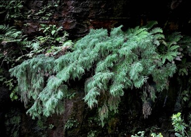 Figure 1: Dwarf Mountain Pine. Source: katoombalocalnews.com
The swamps feed the Katoomba Falls area - habitat for the critically endangered Dwarf Mountain Pine (Pherosphaera fitzgeraldii) (DCCEEW, 2025), shown in Figure 1. The entire global population of this tiny pine is restricted to a few waterfalls along the southern escarpment of the upper Blue Mountains. Any change to the waterflow at these headwaters has direct consequences for its survival.
Peat swamps on sandstone at altitude extremely rare. Their formation depends on the very slow erosion of the Blue Mountains sandstone plateau over millions of years (DCCEEW, 2021).
What These Swamps Need to Stay Healthy
The swamps downslope from the proposed development (see Figures 2 & 3) are high groundwater-dependent ecosystems. They rely on continual recharge from groundwater seepage. Rainfall on the ridgetop infiltrates through the sandstone until it meets impermeable layers of claystone, ironstone and shale. Water is then forced out and emerges as springs or seepage lines that feed the swamps below (BMCC, 2010).
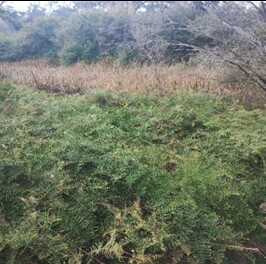 Figure 2: Swamp downslope from proposed development site. Source: T De Bortoli
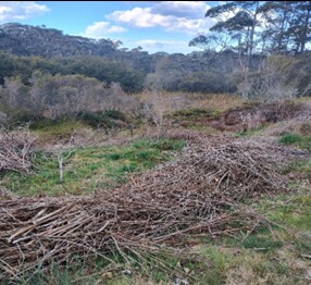 Figure 3: Piles in the photo above are weeds which have been removed. Source: T De Bortoli
Forest on the ridgetop acts as a protective buffer, increasing infiltration and reducing surface run off and erosion. These ridgetop woodlands, (Footnote 2), along Narrow Neck Road are part of the natural system that keeps the swamps functioning.
How the Proposed Development Threatens the Swamps
Blue Mountains Swamps are highly sensitive to changes in hydrology - particularly shifts in water flow and groundwater levels.
The scale of the proposed development would introduce a large area of hard, impervious surfaces (roofs, walls, car parks, driveways). Because the site is steep, this concentration of hard surfaces poses two major risks to the swamps.
1. Increased Stormwater Volume and Speed
Hard surfaced dramatically increase the volume and velocity of stormwater and surface water runoff. On a steep slope, this can cause severe erosion of the swamps, including the formation of channels or tunnels (Figure 3). These channels rapidly drain water, drying out the swamps and destroying its structure.
Erosion can also cause swamp banks to slump or collapse. This occurred at Bullaburra after the Great Western Highway widening, where redirected stormwater caused the swamp to collapse, exposing ancient peat. This is an irreplaceable loss, having taken thousands of years to form.
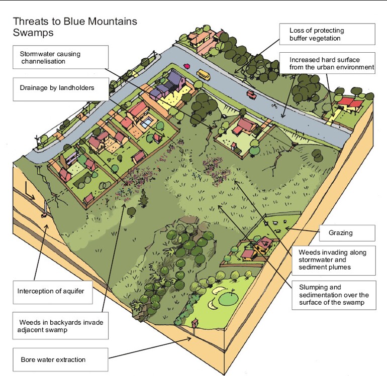 Figure 3: Diagram illustrating threats to Blue Mountains Swamps. (Blue Mountains City Council et al. 2010)
Faster runoff also carries sediments that can smother vegetation, disrupt water flows and degrade habitat. Stormwater can introduce nutrients that fuel weed invasion, further damaging the swamp ecosystem (BMCC, 2010).
2. Reduced Groundwater Infiltration
Impervious surfaces block rainfall from soaking into the ground, reducing groundwater recharge to the seepage lines and springs that deed the swamps. Reduced groundwater leads to drying, vegetation loss, and greater vulnerability to erosion and bushfire (NSW Government Office of Environment and Heritage, 2024).
The proposed development would worsen existing impacts from past clearing, residential development and weed invasion. A local Bushcare group (Footnote 3) is actively working to restore the swamps - efforts that would be undermined by hydrological disruption from large-scale construction upslope.
Implications of Swamp Degradation
Erosion, sedimentation, nutrient enrichment and weeds all compromise swamps' ability to regulate water and support wildlife.
Severe degradation would reduce habitat for threatened species - including the Dwarf Mountain Pine, which is already at risk of extinction. It could also allow polluted, sediment-rich water to enter the Blue Mountains World Heritage Area and the Sydney drinking water supply, undermining its ecological values and contaminating a critical water catchment.
Footnotes:
1. The Plant Community Type is Blue Mountains Swamp Heath. This vegetation community is associated with Blue Mountains Swamps in the Sydney Basin Bioregion, which is listed in NSW as a Vulnerable Ecological Community under the Biodiversity Conservation Act 2016. Further, this vegetation community is a component of the ecological community Temperate Highland Peat Swamps on Sandstone, which is listed as Endangered under the Federal Environment Protection and Biodiversity Conservation Act 1999.
2. The Plant Community Type is Upper Blue Mountains Ridgetop Woodland. This is a common vegetation community found extensively across the higher elevations of the Blue Mountains from 750m to 1200m above sea level. It is associated with the Sydney Montane Dry Sclerophyll Forests vegetation community. While it is not listed as threatened, it is associated with 118 threatened species, including the Blue Mountains Water Skink (Eulamprus leuraensis).
3. For more information about Bushcare and the Planetary Health Initiative Bushcare group, see Bushcare Blue Mountains at https://bushcarebluemountains.org.au/groups/
References
Department of Climate Change, Energy, the Environment and Water (DCCEEW), 2021, Temperate Highland Peat Swamps on Sandstone, Department of Climate Change, Energy, the Environment and Water, Australian Government, accessed online 12 December 2025.
https://www.dcceew.gov.au/environment/biodiversity/threatened/assessments/temperate-highland-peat-swamps-2005
Department of Climate Change, Energy, the Environment and Water (DCCEEW), 2024, Approved Conservation Advice for Temperate Highland Peat Swamps on Sandstone, available online.
Department of Climate Change, Energy, the Environment and Water (DCCEEW) 2025, Protected Matters Search Tool interactive map, (https://pmst.environment.gov.au) accessed online 12 December 2025.
Blue Mountains City Council et al (BMCC) 2010, Soft-engineering solutions for swamp remediation – a ‘how-to’ guide, Save our Swamps Program, accessed online 12 December 2025.
https://www.bmcc.nsw.gov.au/sites/default/files/document/files/SWAMPREMEDMANUALSECTIONONEFINAL.pdf
NSW Government Office of Environment and Heritage, 2024, Blue Mountains Swamps in the Sydney Basin Bioregion - profile, NSW Government, accessed online 12 December 2025.
https://threatenedspecies.bionet.nsw.gov.au/profile?id=20071
You'll receive regular information and updates on the Society campaign to oppose this development, and its many other activities.
We acknowledge the traditional custodians of this land
the Darug and Gundungurra people
and pay respect to their Elders past and present.