 Image of development from the EIS
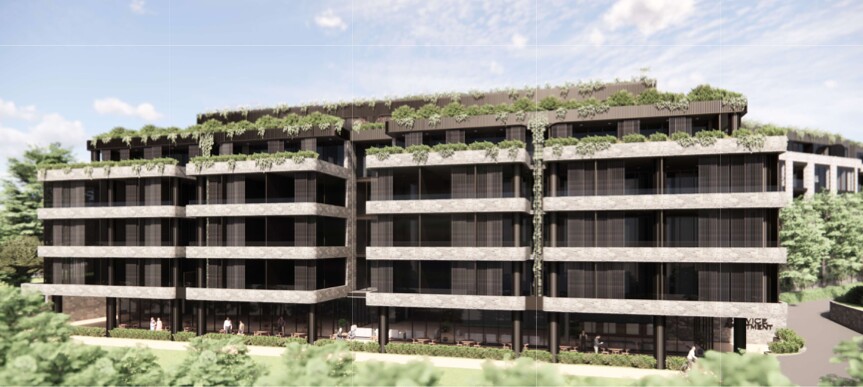
142–150 Narrow Neck Road, Katoomba
The proposed development is likely to change water flows from the site, with impacts for adjoining properties and the watercourses and swamps downslope.
Characteristics of the site that have implications for water management
Soil characteristics
The soil on the site is:
- sandy,
- highly permeable,
- highly erodible,
- shallow, and
- acidic, ranging in pH from 4.5 to 6.0.
The soil is highly susceptible to erosion, particularly when ground cover is disturbed and water flows are concentrated as a consequence of urban development and after bushfire. Therefore, the soil on the site presents significant limitations for development and earthworks (NSW Department of Planning, Industry and Environment, 2026).
Slope constraints
According to the Blue Mountains Local Environment Plan 2015, the development site has Protected Areas – slope constraint, where the slope is 20-33%. Development on these areas of the site should be restricted, to minimise soil disturbance, and vegetation clearing (Blue Mountains City Council, 2015a).
Groundwater
The development site is likely on groundwater that is a perched aquifer, which recharges the groundwater dependent ecosystems (Blue Mountains Swamps) downslope. Perched aquifers “can be depleted rapidly in the absence of continuing recharge” (Blue Mountains City Council 2015b, p223). The scale of the proposed development is likely to reduce groundwater recharge and therefore have an adverse impact on the swamps.
Likely impacts of development on this site
The scale of the proposed development will likely leave little pervious ground on the site.
The combination of soil properties, erosion hazard and steep slope with the coverage of hard, impervious surfaces, risks changing water flows in two major ways that will impact the soil and groundwater on the site and nearby swamps
- The first way is through collecting an increased volume of stormwater and concentrating its flow, including speed of flow, as surface water run-off. Given the high erodibility of soil on the site, the proposed development is likely to cause significant soil erosion and sedimentation both on the site and downslope on adjoining properties
- The second way is by interfering with the high permeability of the soil through blocking the infiltration of water into the ground. This reduces the flows of groundwater to the swamps near the site (Blue Mountains City Council et al., 2010.
The use of concrete would also change the pH of the soil and water that runs off it. Water runoff from concrete infrastructure increases the pH (more alkaline) of soil. This could threaten native vegetation both on and downslope from the site. It would also allow invasive weeds to grow where they would otherwise struggle to survive. (Ramage, 2024).
What might happen is water is not managed on the site
The proposed development is situated within the Sydney Drinking Water Catchment. The developer is required to show how they would prevent or minimise the sorts of impacts described above.
The developer is required to:
- Control the quantity and quality of water that leaves the site during and after development,
- Control erosion and sedimentation, and pollution movement downslope during and after development, and
- Manage wastewater from the development on site (Blue Mountains City Council, 2015b; WaterNSW, 2023).
The adjoining Escarpments development provides an example of what can happen if these issues are not addressed. It was completed under a “zombie DA” that was not required to consider stormwater management. Jennifer Buick, who lives on an adjoining property, reports that significant flooding and sedimentation affected her property and the old golf course during construction and recurs whenever there is sustained rainfall, as shown in the images below. Follow these links link 1 and link 2 for video footage.
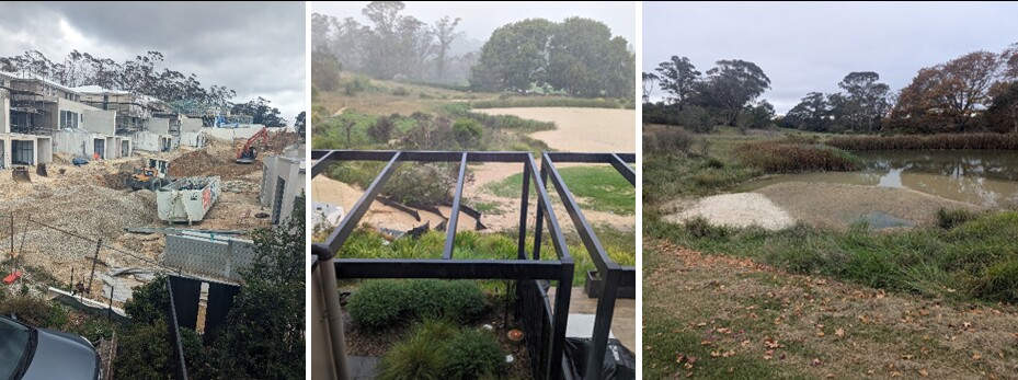 Figure 1: Footprint of The Escarpments during construction (left), stormwater breaching erosion control fences (middle) and causing sedimentation to the watercourse below (right). Source: Jennifer Buick.
References
Blue Mountains City Council. 2015a. Blue Mountains Local Environment Plan 2015.
https://legislation.nsw.gov.au/view/html/inforce/current/epi-2015-0829
Blue Mountains City Council. 2015b. Development Control Plan 2015.
https://www.bmcc.nsw.gov.au/development/planning-rules/development-controls-for-land-zoned-under-LEP-2015/DCP-2015
Blue Mountains City Council et al. (2010). Soft-engineering solutions for swamp remediation – a ‘how-to’ guide.
NSW Department of Planning, Industry and Environment. 2026. eSPADE v2.2, Medlow Bath Soil Landscape.
https://espade.environment.nsw.gov.au/
Rammage, L. 2024. Impacts of Concrete on Blue Mountains Sandstone Ecology. Blue Mountains Conservations Society
WaterNSW. 2023. Developments in the Sydney Drinking Water Catchment – Water Quality Information Requirements. A WaterNSW Current Recommended Practice.
https://www.waternsw.com.au/documents/publications/water-services/Developments-in-the-Sydney-Drinking-Water-Catchment.pdf
You'll receive regular information and updates on the Society campaign to oppose this development, and its many other activities.
We acknowledge the traditional custodians of this land
the Darug and Gundungurra people
and pay respect to their Elders past and present.