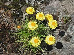
 Pagoda Rock Daisies (Leucochrysum graminifolium)
It is a land of rock pagodas, natural sandstone pinnacles, endangered ecological communities and threatened plant and animal species.
Here is a video setting out the wonders of this important place The Gardens of Stone
This area should be protected for its conservation values under the National Parks and Wildlife Act.
The sandstone pagoda landscapes extending from Newnes Plateau to the Capertee Valley are generally regarded as the most impressive, well-developed and accessible in the area. This is where the 'platy' pagoda with its distinctive ironstone banding is particularly prevalent. About half of the 60,000-hectare platy pagoda heartland is protected within the Greater Blue Mountains World Heritage Area, yet the remaining half is in Mugii Murum-ban State Conservation Area and the unprotected Gardens of Stone Stage Two area.
Pagodas occur throughout most of Gardens of Stone Stage 2 reserve proposal, on plateau edges, headwater valleys and spur lines descending towards gorges where deep weathering exposes sandstone 'corestones'.
"The 'platy' is globally rare with considerable uncertainty about how the characteristic ironstone bands which control the eroded shape are formed" (Washington and Wray). The smooth pagodas are of national significance, yet the platy pagodas are considered to be of international significance.
This pagoda terrain is significant for the local ecology, with the rare Pagoda Daisy found only in this habitat. The intricate, rocky topography that it creates - of ledges, overhangs, caves, cracks and chasms - provides a complex variety of habitat, moisture and microclimate. Lichens, mosses, vascular plants and wildlife all exploit this diversity, shown by the prevalence of Rock Warblers, Lyre-bird nests and the plant 'community'.
The pagoda land system of all three elements (pagodas, steep slopes and valley floors) is necessary to support the animals which live and forage there.
A 2012 Planning Assessment Commission (PAC) review found that:
- the pagodas cannot be considered in isolation...they are part of a landform consisting of multiple pagoda structures and intervening sections of cliffs, with steep slopes and dissecting gullies below.
- The 2012 PAC Review Report found that the area has a unique landscape and significant levels of biodiversity.
- The pagodas are considered to be internationally significant geological features some 250 million years old and worthy of total protection (see footnote)
- In 2014 PAC a second Planning Assessment Commission concluded again that "the pagoda landform complex is a natural feature of special significance and that the features warrant the highest level of protection, i.e. they should be fully protected from risks of mine induced impacts".
- The pagodas are...a unique landform on a world scale…have limited distribution…provide critical habitat for some flora species and key habitat features for threatened fauna; and
- The pagoda landform should be afforded special significance status and the highest possible level of protection.
The complex topography creates a diversity of exposure across the area, from sheltered canyons to exposed plateaus and hill tops. These in turn promote a variety of ecosystems, plants and animals.
The Proposal would protect more than 1,000 plant species and many plants and communities that are threatened, have limited distribution and are outside the current reserve system.
Vegetation types include rainforest, wet sclerophyll forests, dry sclerophyll forests, woodlands, grassy woodlands, swamps, heaths and riverine forests. These communities occupy a range of environments including high plateau tops, swamps, exposed rocks, watercourses, sheltered slopes and canyons.
The Proposal would protect at least 319 vertebrate species, including 40 threatened species and two endangered invertebrates.
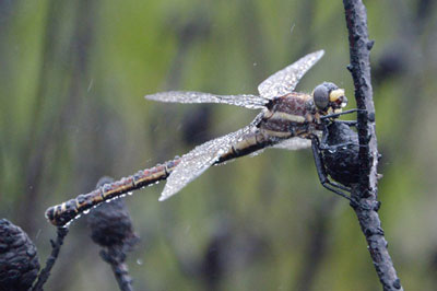
The escarpment and pagoda provide greater diversity for fauna habitat, supporting the endangered Broadhead Snake, Lesueur's Gecko, Heath Monitors, Brown Anthechinus and Bush rats, gliders and possums. Swamp heaths provide a different habitat again and comprise a significant proportion of habitat for the Blue Mountains Water-skink and Giant Dragonfly (endangered), while the Bathurst Copper Butterfly (endangered) is reported too. There are also seven threatened bat species.
The Squirrel glider, Eastern Cave Bat, Southern Myotis, New Holland Mouse, Powerful Owl, Glossy Black Cockatoo, Regent Honeyeater, Scarlet Robyn, Sooty Owl and Spotted-tail Quoll are all threatened animals that live in the area too. The Regent Honeyeater is critically endangered.
The upland peat swamps are a significant feature of the area and classified as endangered under both state and national legislation.
The swamps, dating back to 10,000 years, are a key habitat for a variety of flora and fauna, including the endangered Blue Mountains Water Skink and Giant Dragonfly, as well as several threatened plant species.
Classified as Newnes Plateau Shrub Swamps and Newnes Plateau Hanging Swamps, the majority of swamps (490 hectares) are at risk and lie unprotected, with many of the areas best swamps in the headwaters of Carne Creek area (Newnes Plateau).
Swamps play an important role by slowing down and filtering water.
The Gardens of Stone Stage 2 reserve proposal contains identified wilderness within Newnes State Forest. This wilderness would make a significant contribution to enhancing the protection of intact ecosystems contiguous with the Greater Blue Mountains World Heritage Area. It was not included in 361,000 ha wilderness declared within Blue Mountains and Wollemi National Parks in 1991 which was the largest formally protected wilderness in Australia
Totalling 55,000 hectares, over 70 percent of the Gardens of Stone area remains unprotected and threatened by mining.
The Gardens of Stone area is also important for the role it plays in providing drinking water supplies, locally and to Sydney's drinking water catchment.
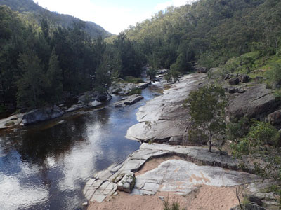 Coxs River (Philip Jackson)
The Coxs River provides 30% of the water in Warragamba Dam. The boundary of Sydney's drinking water catchment is shown on the Society's Area of Interest map.
The water from Warragamba is used by 4.5 million people living in Sydney and the lower Blue Mountains. You can learn more about Sydney's drinking water area here.
A recent court challenge by environmental organisation, 4nature, sought to strengthen these protections. You can read about 4nature's court action and the outcome here.
Reservoirs on the upper Coxs River also supply water for Lithgow and nearby Mount Piper Power Station.
Water from the Wolgan and Colo Rivers supplies properties in the upper Wolgan Valley and lower Colo Valley. The Turon River traverses Turon National Park and ultimately arrives at Macquarie Marshes Nature Reserve (a wetland of international importance) - all the Gardens of Stone Stage 2 reserve proposal catchments feed water into important conservation reserves.
Footnote: DPE Coalpac Consolidation Project (10_01 76) Addendum Report - 7 August 2013. P.6
We acknowledge the traditional custodians of this land
the Darug and Gundungurra people
and pay respect to their Elders past and present.