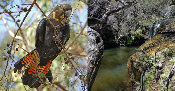
 Glossy Black-Cockatoo & Katoomba Creek (Jill Dark & Lyndal Sullivan)
The Blue Mountains Conservation Society is proposing these additions to the Blue Mountains National Park. This would require an assessment by the National Parks and Wildlife Service (NPWS) to determine whether to acquire them and add them to the Blue Mountains National Park.
It is important to note that acquisition by the NPWS of privately held land to add to the national park system is via negotiation. Privately held land is not compulsorily acquired for addition to the national park system.
The inclusion of these areas into the Blue Mountains National Park will protect areas of conservation significance which have threatened species, geological features and/or aboriginal heritage.
Each of the areas either consolidate or rationalise existing National Park boundaries to improve management for conservation.
Most have increasing recreational use, requiring active management to avoid degradation.
West Glenbrook
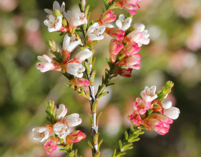 Fringed Heath-myrtle (Micromyrtus ciliata) (Mark Baker)
The floristic abundance of its sandstone fringes and escarpments includes unusual and rare flora species. It is a place of Aboriginal cultural significance.
The addition of the West Glenbrook site to Blue Mountains National Park would:
- Logically re-align the National Park boundary in this location by eliminating a virtual in-holding
- Allow for the conservation of the Threatened Shale/Sandstone Transition Forest Ecological Community, and a significant collection of other threatened or rare plants and animals
- Better manage the water resources of Glenbrook Creek and the wider Hawkesbury/ Nepean River
- Protect Aboriginal heritage including sandstone occupation sites and traditional pathways
- Provide a plan for the management of popular but currently uncontrolled recreational activities
- Increase the resources and expertise allocated to manage other current issues that include weed and feral animal control, the intrusion of residential activities and fire hazard reduction.
Here's the NPWS Strategic Additions Summary for West Glenbrook.
Faulconbridge Mallee Ridge
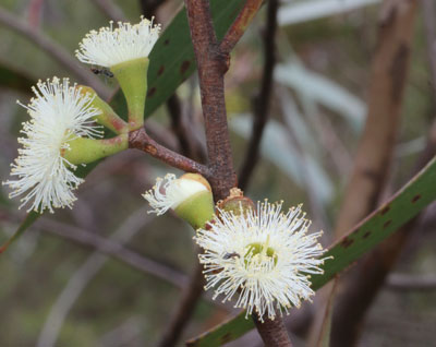 Faulconbridge Mallee (Eucalyptus burgessiana) (Mark Baker)
It is a critical site for the rare Faulconbridge Mallee Ash (Eucalyptus burgessiana) and provides habitat for a range of threatened species. It is a place of significant Aboriginal cultural heritage.
The addition of the Hillcrest Ave and Meeks Cr properties to the National Park would:
- Consolidate land with great conservation values including substantial biodiversity, threatened species, rare/unusual plants and the critical habitat of Eucalyptus burgessiana into the one management organisation, and would remove the possible future threat of residential expansion
- Provide for the protection and appropriate management of very important Aboriginal heritage sites that are continuous with others elsewhere along the southern rim of Linden Creek
- Minimise future negative impacts of changes in water runoff quantity and quality, through the National Park and World Heritage Area into the Grose River, a designated Wild River in NSW
Here's a map of Faulconbridge Mallee Ridge.
Here's the NPWS Strategic Additions Summary for Faulconbridge Mallee Ridge.
Kings Tableland
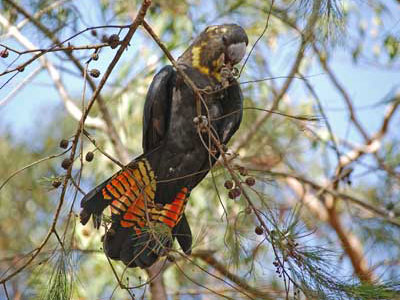 Glossy Black-cockatoo (female) (Jill Dark)
The Glossy Black-Cockatoo is species-dependent, relying heavily on the Allocasuarina distyla (Scrub She-oak) growing here as a major food source.
The annual Honeyeater migration regularly pauses here for food and rest in April & May, returning throughout Spring each year. Butterflies migrate in huge numbers during October & November, feeding on the many white-flowering species present.
The addition of the Kings Tableland site to the Blue Mountains National Park would:
- Significantly reduce the size of the present inholding, meaning the boundary length requiring maintenance would be reduced from current ~13.75 Km to under 4Km (1.8 + 1.6). The area of inholding would reduce from ~380 ha to under 40 ha (in two lots).
- Protect Aboriginal heritage likely existing here.
- Enhance the existing National Park through the large number of swamps present within this property.
- Better manage the water resources from the Queen Victoria Creek flowing from the property directly to the Nepean/Hawkesbury River system and the through the Jamieson Creek/Kedumba River system to Sydney drinking water supply.
- Normalise the current bushwalking activities, which can be seen as trespassing on private property.
- Allow vehicle access to be more easily regulated, reducing many of the threatening processes outlined above.
Here's a map of Kings Tableland.
Here's the NPWS Strategic Additions Summary for Kings Tableland.
Govetts Creek Catchment
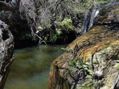 Katoomba Creek (Lyndal Sullivan)
It will provide a continuous corridor of protected natural areas by linking the isolated section of National Park around Cascade Dam to the main area of the existing National Park and the Minnehaha Falls Crown Reserve. These missing lands along Govetts Creek are also important for the endangered Blue Mountains Swamps they each contain.
The addition of the 3 parcels in the Govetts Creek Catchment to the Blue Mountains National Park would:
- Logically re-align National Park boundaries by eliminating some virtual inholdings, improving boundaries for management of the existing national park, and consolidate the area of the Blue Mountains World Heritage Area.
- Provide more adequate buffers to the public reserves from adjoining urban land uses, in particular for some protection against weeds.
- Allow for the better management of the Katoomba and Govetts Creek watercourses and hence the Grose River.
- Provide more protection for the threatened Blue Mountains Swamps and the endangered species living within them; viz Eulamprus leuraensis and Petalura gigantea; and for Epacris hamiltonii, which is restricted to small rock overhang sites above the creeklines.
Here's a map of the Govetts Creek Catchment.
Here's the NPWS Strategic Additions Summary for Govetts Creek Catchment.
We acknowledge the traditional custodians of this land
the Darug and Gundungurra people
and pay respect to their Elders past and present.